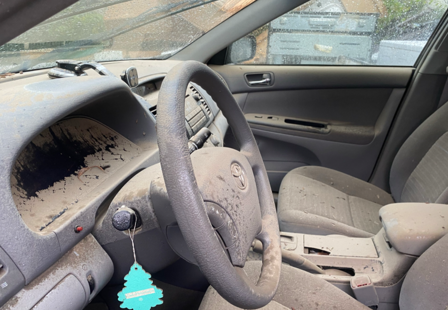
“It was like the apocalypse,” a resident at the Avalon Apartment Building proclaims. “I was in California on a work trip when Hurricane Ida hit Mamaroneck…but when I returned, it was like nothing I had ever seen. Everything was flooded. Homes, businesses, my car [which got totaled], the roads…everything.”
Hurricane Ida, which landed in New York on September 1st, 2021, produced flood levels up to 14 feet, displacing hundreds of families and destroying costly infrastructure, particularly near the Mamaroneck Train Station, where the Avalon is located. Mamaroneck residents faced large amounts of dangerous stormwater that continues to affect our community today.
To understand the stormwater’s impact on the Village of Mamaroneck, it is important to consider the geography of our town and its natural landscapes. There are several reasons why Mamaroneck is so susceptible to flooding. First, much of the land is in low-lying areas, making the three narrow rivers that flow through Mamaroneck- the Sheldrake River, the Mamaroneck River, and the Beaver Swamp Brook – more likely to overflow. These river’s watersheds, which are the areas surrounding and draining into the rivers, encompass a 24-square-mile region stretching across Westchester County. The Village of Mamaroneck is located at the bottom of these watersheds, meaning the stormwater from upper Westchester County naturally flows into Mamaroneck and amplifies flooding that already occurs during major storms.
Furthermore, the Village rests upon a substantial, underground reserve of water known as an aquifer, which will be studied to determine the effects on groundwater flooding. Tony Gelber, Chair of the Village of Mamaroneck Flood Mitigation Advisory, states that these combined conditions make “Mamaroneck the New Orleans of Westchester County.”
Unfortunately, many residential and commercial developments occupy this flood-prone area, putting them at the mercy of storms such as Hurricane Ida. The Village of Mamaroneck has been scrambling for years to figure out how to effectively mitigate the severe flooding, flooding that has led to the death of three village residents in the past 25 years, one during Ida. While it has been an ongoing and extensive process, the Village has recently implemented some significant changes that aspire to modify Mamaroneck’s natural landscape, most notably the Army Corps Flood Project.
The US Army Corps of Engineers Flood Project, the largest flood mitigation initiative in the Village of Mamaroneck, was finalized in 2017 after facing bureaucratic hurdles for decades. It was only after Senator Chuck Schumer accelerated approval of the plan in the wake of Ida that funding came in 2021.
The project is estimated to cost 88 million, a bill entirely subsidized by the federal government. In 2017, New York was required to pay 35% of the bill but was relieved of this responsibility after Hurricane Ida, where Schumer advocated for the federal government to cover all costs in light of the damages the hurricane caused.
The plan aims to reduce flood-related damages in the Village of Mamaroneck by 3.4 million dollars annually and manage the risks that stormwater overflow poses to residents and property.
The Army Corps plans to accomplish these goals by widening and deepening the Mamaroneck and Sheldrake River channels to create more space for water flow. The wider channels will be achieved through a combination of sloped earth with vegetation, rip rap rock and some concrete. These measures are estimated to create a 2.8-4.6 foot reduction in water surface elevations, hopefully lessening the risks and severity of flood-related damages and costs. The project also details plans to remove/replace bridges in the Village of Mamaroneck, such as the Ward Avenue Bridge and the pedestrian bridges near Columbus Park.
While the Army Corps Project has been met with widespread enthusiasm in our community, some stakeholders have concerns about the effectiveness of its plans. Village residents have voiced concerns over the project’s failure to address groundwater aquifer flooding, as it only focuses on river water flooding, while others worry about the impacts on the 88 private landowners expected to be displaced by the project. The Army Corps plans to obtain 14 acres of land that residents and businesses currently occupy through eminent domain to stage necessary constructions.
Another concern is the possible detrimental impact on the environment, with the US Fish and Wildlife Report 2015 stating that the project “will adversely affect riverine, palustrine, and terrestrial ecosystems of the Sheldrake and Mamaroneck Rivers.” Tony Gelber, the Chair of the Village of Mamaroneck Flood Mitigation Committee, shares some of these concerns and believes the Army Corps Plan does not address flooding to the extent it could. He suggests that for Mamaroneck to truly combat this issue, we must look beyond our town borders and dive into the full depth of the 24-mile watershed created by the Mamaroneck, Sheldrake, and Beaver Creek Rivers through the “Holistic Watershed Plan.”
While the Army Corps Project is limited to the boundaries of Mamaroneck, Gelber explains that the Holistic Watershed Plan will target all 24 miles of the watershed and, in doing so, will not only address the river flooding at the Village of Mamaroneck but will also consider the Mamaroneck Reservoir and Dam, Saxon Woods, runoff from I-95 and the Hutchinson Parkway, and the groundwater in the Mamaroneck aquifer. The principal concept is to “retain and detain water,” Gelber says, hoping this broader approach will mitigate flooding at the source.
Gelber also explains how the Holistic Watershed Plan aims to “tighten stormwater regulations” by creating stricter guidelines on the structures that property owners can build in Mamaroneck. He believes that new developments or extensive renovations should withstand a 250 or 500-year flood, a flood of such a size that it has a 1/250 or 1/500 chance of occurring each year. Currently, properties in Mamaroneck meet a much lower standard despite being in a flood-prone area. Furthermore, with climate change amplifying the severity and frequency of major storms, extreme events such as a 500-year flood are becoming more common. In and surrounding New York City, these 1/500-year events occur on average once every 24 years. According to Gelber, it would be prudent to update our zoning policies to protect Mamaroneck citizens from these increasingly common natural disasters. Zoning changes like these are not part of the Army Corps Project.
Another aspect of the Holistic Watershed Plan is encouraging green infrastructure. According to Gelber, the Army Corps Project utilizes gray infrastructure to mitigate flooding, referencing artificial methods that work against nature, such as dams, pipes, drains, and gutters. The principal idea of green infrastructure is to work with nature by mimicking natural systems to manage rainwater runoff. A primary example of green infrastructure is a green roof, which is a roof covered with vegetation planted over a drainage system. Other means, such as permeable pavement, allow water to soak into the ground during heavy rain. In the future, Gelber hopes to develop programs and obtain grants to incentivize property owners to invest in green infrastructure for their homes. To start, suppose homeowners install infrastructure such as a green roof or permeable pavement. Gelber hopes that these changes will be reflected by a rise in property values, as the infrastructure would protect their homes against significant flooding to a greater degree than the surrounding buildings.
While it is easy to speculate about the benefits of the Holistic Watershed Plan, it is much harder to put the plan into effect. Extensive zoning codes and layers of government administration make it a lengthy and challenging process to approve significant projects. Take the Army Corps Project, for example; the Village advocated for flood mitigation along the Mamaroneck and Sheldrake rivers as early as 1986, the plan was finalized around seven years ago, in 2017, but funding was still not approved until 2021. The demolition of the Ward Ave Bridge is not set to begin until 2024. Gelber stresses that any in-depth project “will not happen overnight,” but he believes that the future of flood mitigation in Mamaroneck rests in the Holistic Watershed Plan.
Currently, Gelber says, the Village of Mamaroneck is working on ‘parallel projects’ including removing silt and debris from the Rivers, cleaning storm sewers regularly, fundraising for future projects, investigating ways to detain and retain water, and tightening the stormwater regulations.
While these plans are underway, Mamaroneck residents can continue to take small actions that prepare for future flood risks. We can take strides to understand the risks we face while living in a flood zone, build strong ties with our neighbors, and help prevent climate change through recycling, composting, and energy-efficient transportation methods. The town can also take smaller steps to mitigate flooding, such as ensuring that our gutters are clear and unblocked by debris and creating more awareness about the dangers of flooding. Unfortunately, due to our location and being an almost fully built out community, flooding will always be a danger our town will face. However, we can take steps to lessen its negative impact and protect our community from its threats through intelligent planning, technology, and collaboration.


